 Jam SQL Studio
 PostGIS Viewer: See Your Geometry on a Map
Run a query, get a map. Jam SQL Studio decodes PostGIS geometry and geography (EWKB) and renders it right in the results grid, a peek popover, a Query Editor Map tab, and a multi-layer Spatial Explorer — on Mac, Windows, and Linux.
Free for personal use • No account required • Mac, Windows, Linux
If you keep spatial data in PostGIS, you eventually want to see it — not read a hex blob of EWKB in a results grid. A good PostGIS viewer turns ST_AsEWKB(geom) into shapes on a map without an export/import dance. Jam SQL Studio does that inside the SQL client you already query from: geometry columns are recognized automatically, summarized in the grid, and one click away from a map.
pgAdmin's built-in Geometry Viewer, DBeaver's GIS viewer and DataGrip's Geo viewer all plot PostGIS results, and QGIS (4.2 is the current release, 3.44 the long-term one, as of September 2026) is the reference desktop GIS for editing map data. Jam SQL Studio's angle is different: it is a cross-engine SQL IDE that also maps geometry from PostGIS and MySQL, SQL Server, Oracle, and SQLite — with per-cell peek maps, map-area filter chips that write SQL for you, and stacked query layers.
PostGIS Viewer Comparison
How Jam SQL Studio compares to other ways of viewing PostGIS geometry on a map.
| Question | Jam SQL Studio | pgAdmin 4 | DBeaver | DataGrip | QGIS |
|---|---|---|---|---|---|
| Map PostGIS geometry from SQL results | ✓ | ✓ Geometry Viewer | ✓ GIS viewer (Community) | ✓ Geo viewer | Via layers and DB Manager |
| Limits and formats | All PostGIS types incl. curves; feature cap set per layer | Up to 100,000 geometries / 20 MB; 2D and 3DM EWKB, no curve types listed | — | WKT, WKB and SRID 4326 geometry; needs JCEF | Full GIS |
| Basemap | ✓ OpenFreeMap, opt-out | OpenStreetMap only when SRID is 4326; custom tile URL | ✓ Predefined and custom tile layers | — | ✓ |
| Works offline | ✓ Planar graticule, no network | ✗ Internet connection required | — | — | ✓ |
| SRIDs other than 4326 | ✓ Built-in + bundled EPSG table, then spatial_ref_sys, then planar | Draws one SRID per map; OSM tiles only at 4326 | — | — | ✓ Full reprojection |
| Also maps MySQL / MSSQL / Oracle / SQLite | ✓ 5 engines | ✗ PostgreSQL | ✓ MySQL, SQLite free; SQL Server, Oracle in PRO | PostgreSQL tables and CSV/XLSX files | Via GIS layers |
| Copy WKT / Copy GeoJSON from a cell | ✓ | Via query | Via query | — | ✓ Export |
| Filter rows by map area, emitted as SQL | ✓ Bounding box, distance, drawn polygon | — | — | — | Via GIS filters |
| Stack several query results as layers | ✓ Spatial Explorer | — | One result per viewer | — | ✓ |
| Map lat/lng or WKT text columns | ✓ Declare in MetaInfo | — | — | WKT/WKB values | ✓ Delimited-text layer |
| Edit stored geometry | ✗ View, filter and export | — | — | — | ✓ Full GIS editor |
| Price | Free for personal use; Pro $99/year | ✓ Free | ✓ Community free | Free non-commercial; $109/year | ✓ Free, open source |
How to View PostGIS Geometry in Jam SQL Studio
From a raw geometry column to a map in a few clicks — no export, no GIS project setup.
Run any query that returns geometry
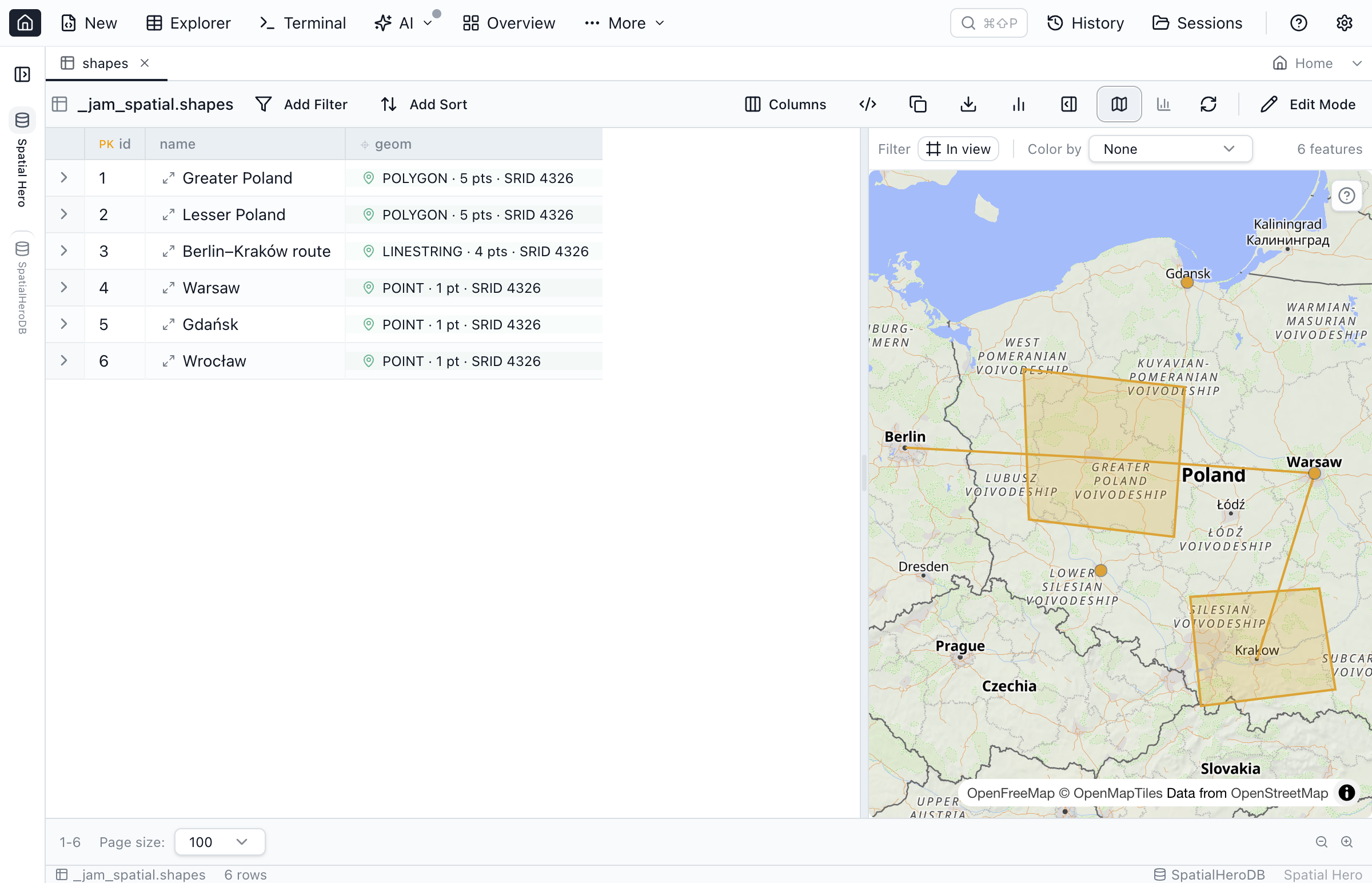
Connect to your PostgreSQL/PostGIS database and run a normal SELECT. Jam SQL Studio recognizes geometry and geography columns and shows a one-line summary in the grid — for example POLYGON · 5 pts · SRID 4326 — instead of an opaque EWKB blob.
Peek a single feature
Click the peek button on any spatial cell to open a fit-to-data mini map. From there you can Copy WKT or Copy GeoJSON, and for large geometries a Load full geometry action pulls the rest on demand.
Plot the whole result set on the Map tab
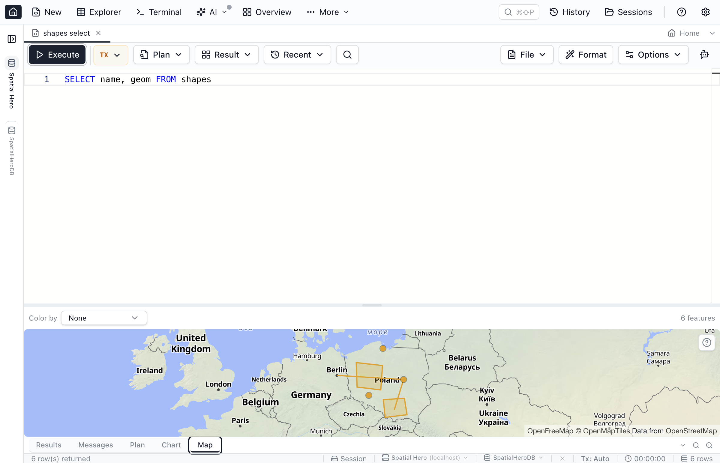
Switch the Query Editor results to the Map view to see every row together, colored by a column of your choice with a live feature count. SRIDs resolve through built-in projections and a bundled definition table first, then the connection's spatial_ref_sys, with a planar fallback when a projection can't be found.
Browse and filter by map area
Open a table in the Table Explorer and use the map pane for two-way selection — click a row to highlight its feature and vice versa. Add bounding-box or distance filter chips and Jam SQL Studio writes the PostGIS predicate for you; In view constrains rows to the visible extent, and Draw area lets you trace a polygon and keep only the rows inside it. On the map, J and K step through features, holding M measures a distance, and pasted WKT or dropped GeoJSON is drawn for comparison.
Overlay multiple layers in Spatial Explorer
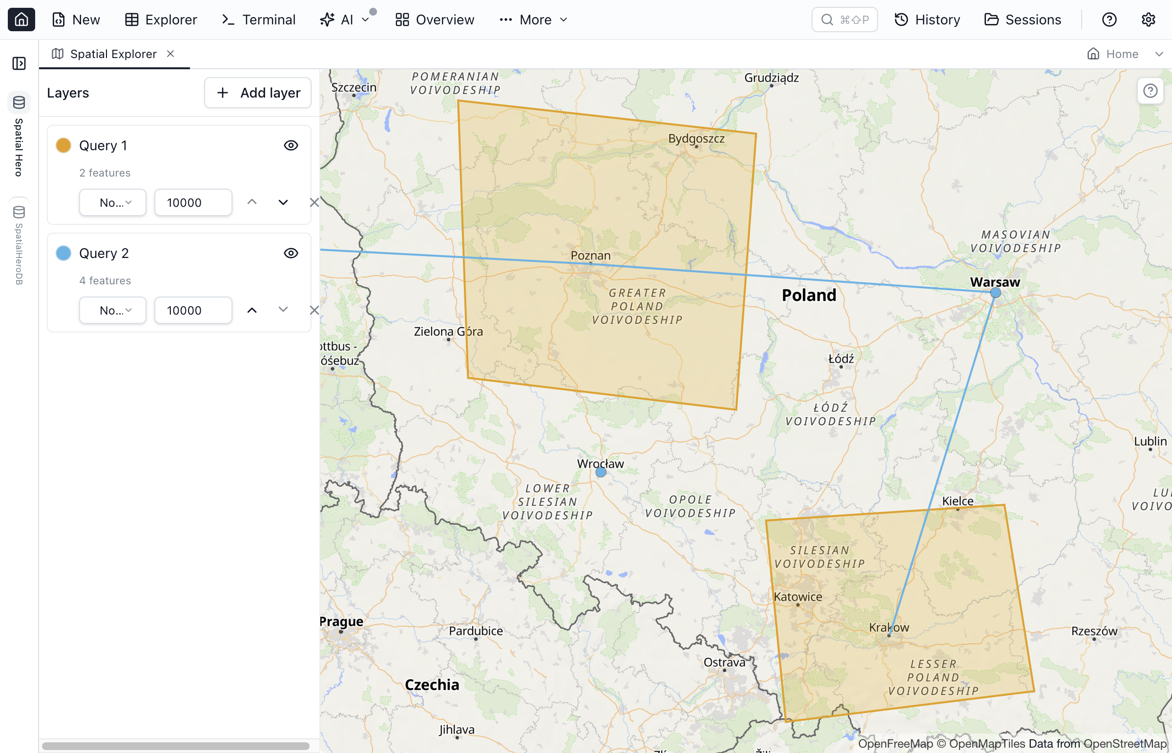
The dedicated Spatial Explorer workspace stacks several query or table layers, each with its own color, label column, feature cap, order, and visibility — handy for comparing, say, routes against zones. Label columns render on the map, and a zoom-to-fit control brings every layer back into view. Full details are in the spatial guide.
A PostGIS Viewer Built Into Your SQL Client
Visualize, inspect, and export spatial data without leaving the query workflow.
Grid Summary & Peek
Spatial cells show a type/point-count/SRID summary and a peek map in both the Query Editor and Table Explorer grids.
Map Results Tab
Plot an entire result set on a basemap, color by a column, and read a live feature count — all from the Query Editor. The same map is available as a tile on SQL Dashboards (beta).
Spatial Filter Chips
Bounding-box, distance and drawn-area filters emit real PostGIS SQL, so a map interaction becomes a reproducible query predicate.
Spatial Explorer Layers
Stack multiple queries and tables as colored layers with labels, caps, ordering, and visibility toggles.
Curves Stay Curved
CircularString and CurvePolygon arcs are linearized for display, while Copy WKT keeps the shape curved (a CircularString stays a CircularString, not the flattened display version).
Declare Coordinate Columns
Have plain lat/lng or WKT text instead of a geometry type? Declare it in MetaInfo and it joins the map surfaces.
Frequently Asked Questions
Common questions about viewing PostGIS geometry on a map.
How do I view PostGIS geometry on a map?
Run a query that returns a PostGIS geometry or geography column. Each spatial cell shows a one-line summary (like POLYGON · 5 pts · SRID 4326) and a peek button that opens a fit-to-data mini map. Switch the results to the Map tab to plot every row together, or open the Table Explorer map pane and the Spatial Explorer workspace for larger, multi-layer maps. It works on Mac, Windows, and Linux.
Does Jam SQL Studio support PostGIS geography as well as geometry?
Yes. Jam SQL Studio decodes both PostGIS geometry and geography from EWKB, reads the SRID, and projects coordinates using a resolution ladder: built-in projections and a bundled EPSG definition table resolve first, a SRID in neither is looked up in the connection's spatial_ref_sys table, and anything still unresolved falls back to a planar fit.
Can I view PostGIS geometry on a Mac?
Yes. Jam SQL Studio is a cross-platform desktop app that runs on macOS, Windows, and Linux, so you can view PostGIS geometry on a map on a Mac without a Windows-only tool or a browser upload.
Does the map send my geometry anywhere?
Geometry decoding happens locally inside the app. The basemap is on by default and fetches map tiles from OpenFreeMap, shown behind a one-time privacy notice. You can turn the basemap off in Settings → Spatial, and the map falls back to a planar graticule that draws with no network — useful offline or when you don't want any tile requests.
Can I draw or edit geometry on the map?
You can draw a polygon on the Table Explorer map to filter rows, but Jam SQL Studio never edits stored geometry or writes shapes back to the database. You can Copy WKT or Copy GeoJSON from any geometry. For authoring and editing geometry, a dedicated GIS editor such as QGIS is the right tool; Jam SQL Studio is the SQL-side viewer, filter and export path.
Which other databases' spatial data can Jam SQL Studio show?
Beyond PostgreSQL/PostGIS, Jam SQL Studio also decodes and maps spatial data from MySQL, SQL Server (both geometry and geography), Oracle (SDO_GEOMETRY), and SQLite (SpatiaLite and GeoPackage). Kusto has no spatial types.
Does it handle curved geometry like CircularString or CurvePolygon?
Yes. On PostgreSQL, Oracle, SQL Server, and SQLite, curved geometry (CircularString, CompoundCurve, CurvePolygon, MultiCurve, MultiSurface) is linearized client-side so the arcs render on the map, while Copy WKT keeps the shape curved (a CircularString stays a CircularString, not the flattened display version). MySQL has no curve types.
How is this different from pgAdmin's Geometry Viewer?
pgAdmin's Geometry Viewer is free and built into the Query Tool: select rows, click View Geometry, and it draws up to 100,000 geometries (20 MB) in EWKB 2D or 3DM types, adding OpenStreetMap tiles only when the SRID is 4326, and it needs an internet connection. Jam SQL Studio also reprojects other SRIDs through spatial_ref_sys, draws curved types, works offline on a planar graticule, filters rows by map area, and stacks several queries as layers, but it is a paid product for commercial use while pgAdmin is free for everyone.
Can I filter PostGIS data by map area?
Yes. The Table Explorer map pane adds bounding-box and distance filter chips that emit PostGIS SQL (ST_Intersects, ST_DWithin), an In view button that limits rows to what is visible on the map, and a Draw area tool: trace a polygon and the grid keeps the rows whose geometry falls inside it, with the polygon reprojected to the column's SRID.
View Your PostGIS Data on a Map
Download Jam SQL Studio free and turn geometry columns into maps on any platform.
Explore More
See how Jam SQL Studio handles spatial data and other databases.
Further reading: Spatial & PostGIS guide · Free WKT viewer · Query Editor · Table Explorer